Chile & Argentina – Part 2

From Ushuaia we flew north to El Calafate, a touristy town that we ended up visiting four times since it is the base for a number of other destinations. On our first visit we only had time to visit the Glaciarium (a museum about glaciers) which had a novel means of telling the weather outside:DSCN9316.JPGThe basement of the Glaciarium is an ice bar. Who was caught raiding the liquor bar?DSCN9321.JPG

From here we took a bus to Puerto Natales in Chile. We then took an unusual route into the national park of Torres del Paine; we arrived by boat. The first part was a very windy sightseeing cruise past mountains and glaciers, where unfortunately Zoë’s beanie hat was taken by the high winds.DSCN9344DSCN9371DSCN9387 Next we boarded an inflatable speedboat and drove like there was no tomorrow up the river towards the park. We felt a tad windswept.DSCN9392.JPGWe arrived to a lovely sunny afternoon, and decided not to waste the good weather and promptly headed up a nearby hill to enjoy the views of the range of Torres del Paine. DSCN9408.JPG

Transport in the park is terrible, but we eventually arranged an expensive shuttle to the start of our hike the next morning and then we were on our way. We were hiking westwards so that our first day would give us an opportunity to see the iconic granite towers that give the park its name. We arrived to find them in the cloud with a pretty dusting of snow, but the cloud almost entirely cleared not too long after.DSCN9415DSCN9432DSCN9447.JPG

Day 2 had crazy weather. We began early and on the first mountain pass saw another hiker lying over a rock to avoid being blown over. The winds ebbed and surged, and at one point later we watched a few foot-long branches being thrown around in the whirlwinds above out heads – thankfully we were on the flat bottom of a valley at this point so could not be blown anywhere too dangerous. The wind also whipped up the water from the lakes into towering plumes of spray that you can just about see in the background of this picture:DSCN9470.JPGThis “four seasons in four minutes” type of weather did make many pretty rainbows too: DSCN9479.JPGAnother famous feature of the park is the dark sedimentary rock sitting on top of the lighter plutonic rock:DSCN9480DSCN9488

Our third day of this trek was the best as we hiked up the scenic French Valley that had been partially closed the day before due to high winds. DSCN9503.JPGDSCN9538.JPGDSCN9509DSCN9527We also saw some avalanches on the other side of the valley which was very cool!DSCN9525.JPGDSCN9537.JPGThe rest of the day was a lovely if long hike to our third refuge, Grande Paine, appropriately named since it was a grand pain trying to reserve two beds there.DSCN9553.JPGIn case you don’t believe us about the weather being rather crazy, here is the official ranger weather forecast. Check out day 3.DSCN9507.JPG

For the last day of our trek we started at first light and powered up to the Grey Glacier which had recently calved a massive iceberg. The early start gave us some extra time to see the glacier before returning to take a boat back to civilisation. DSCN9581DSCN9592DSCN9638DSCN9661DSCN9686DSCN9688DSCN9697DSCN9708

We spent a couple more days in the park after our big hike, this time with a car and taking things a bit easier.DSCN9743.JPGDSCN9768.JPGDSCN9781.JPGDSCN9783.JPGWe did one last hike in the park before leaving. It was so windy at the top that when we stopped and took the bag off we had to put it in a rock cleft and load rocks on top of it to stop it being blown away!DSCN9812.JPGDSCN9804.JPGWe also hiked to a nice viewpoint over Puerto Natales:DSCN9835.JPGDSCN9842.JPG

It seems like everyone in Chile and Argentina is always drinking mate tea from a gourd and a metal straw. So we thought we’d give it a go. The verdict? It was nice, but it’s not a patch on PG Tips.DSCN9848.JPG

Back in El Calafate in Argentina we spent some time hiking, including with crampons on the Perito Moreno glacier. It was all stunning.DSCN9868.JPGDSCN9931.JPGDSCN0033.JPGDSCN0037.JPGDSCN9999.JPGDSCN0057.JPGDSCN0073.JPGAt the time of our visit, the Perito Moreno glacier had extended to reach land on the near side of the lake, creating a temporary ice dam between the two sides of the lake.DSCN0081.JPGDSCN0083.JPGWe had one more day around El Calafate to see more of the area, before finishing off with a lovely fondue complete with fresh vegetables (hard to come by on a restaurant menu in Patagonia!).DSCN0196.JPG

Our penultimate destination of the entire trip was El Chaltén, a quiet town that has three wonderful day hikes leaving right from the town itself, and various nice cafes and bars to relax in after. We’d highly recommend visiting for longer than the two days that most tourists allocated!DSCN0232.JPGDSCN0305.JPGDSCN0338.JPGDSCN0322.JPGDSCN0344.JPGDSCN0462.JPG

We took a tour to Viedma glacier which is retreating at a whopping 500m a year at the moment. We hiked on the rock that had been covered by ice only two years previously which was rather novel!DSCN0265.JPGDSCN0276.JPGDSCN0291.JPG

Our other tour in El Chaltén was a combination of hiking, via ferrata and ice-trekking which made for a rather fun day out!DSCN0393.JPGDSCN0400.JPGDSCN0433.JPGDSCN0445.JPG

Which brings us to the final destination of our trip: Bariloche. This part of Argentina is known as the Lake District and it is easy to see why:DSCN0513.JPG

Our first big hike sounded easy on paper since we began with a chairlift to the summit and then descended 15km around the back of the mountain to reunite with the car at the bottom of the chairlift. We spent two hours exploring around the summit whilst soaking in the views:DSCN0561.JPGDSCN0553.JPGThe next part of the hike was very scenic, but also very tough clambering over boulders along the side of the mountain. It took us about 4 hours to cover 5km!DSCN0565.JPG

The biggest mountain in the area is called Tronodor and we drive to the base of it one day, past some pretty lakes on the way:DSCN0579.JPGThere was a wonderful hike up a steep ridge (a 1:2 gradient) at the base of Tronodor which gave great views of two different glaciers on either side of us.DSCN0595.JPGDSCN0598.JPGNearby was a cool glacier that starts of white, then tumbles over a large rock cliff and reforms at the bottom as a black glacier due to all the debris mixed in with the snow.DSCN0606.JPG

The town has a few chairlifts that give easy views if you’re not interested in hiking:DSCN0623.JPGDSCN0628.JPG

One of our biggest hikes was up Cerro Lopez, with 1200m of ascent. DSCN0648.JPGDSCN0651.JPGDSCN0674.JPGDSCN0671.JPGDSCN0679.JPG

On our last day of the entire trip we started with a drink in the rotating restaurant at the top of one of the chairlifts in town. We then finished the trip in typical style by driving 12km along a challenging dirt road, hiking up 700m to reach a peak and then deciding that the next peak over was much more interesting so traversing over to that one too! DSCN0698.JPGDSCN0699.JPG

And that’s all folks!DSCN0701.JPG

Beyond the end of the world

Antarctica. The first thing we booked, almost the last thing in our trip, definitely the most expensive place we’ve ever visited and without a doubt worth every penny. Antarctica is unlike anywhere else on Earth – there is no government, no infrastructure, no hotels, no hospitals, just a continent which is 98% covered in snow and ice and the rest is bare jagged rocky mountains where the snow can’t settle. In the rest of this blog we hope to persuade you that Antarctica is interesting, beautiful and worth visiting, but before getting stuck into pictures of cute penguins we do not expect that Antarctica is that familiar to everyone, so we’ll give a bit of background.

First things first, before anyone asks about polar bears… they are only found in the Arctic. Antarctica is penguin-land.

It is worthwhile mentioning the importance of climate change on Antarctica and how it will impact the rest of the world:

Firstly, climate change is warming and thus melting the Antarctic ice, which sits on land unlike its Arctic counterpart. Therefore, as it melts, it flows into the ocean and raises the sea level. If it all melted, this would raise sea levels by a whopping 76 meters globally, which would obviously have horrific consequences. 70 meters worth of this water is held in the larger East Antarctic ice sheet which is currently thought to be relatively stable, but the remaining 6 meters is in the West Antarctic ice sheet which is melting fast. The impacts of such a sea level rise would ruin many coastal cities and communities worldwide.

Secondly, the polar regions drive the ocean currents. As the surface of the sea freezes in the winter, the salt from the water is pushed out, making the rest of the water more salty and thus more heavy. This then sinks into the ocean depths, driving ocean currents such as the Gulf Steam – which ensures that the UK enjoys a temperate climate rather than being considerably colder. Less sea ice will alter this system, and the consequences are unlikely to be favourable.

Thirdly, Antarctica has a huge amount of fauna living in the sea and almost all of this depends on a very simple food pyramid, which is being undermined by climate change. Phytoplankton thrive in the mineral-rich waters of the Southern Ocean, and these support krill – small shrimp-like creatures that are eaten directly by penguins, whales and seals alike, and so the krill support basically the entire food chain above them. The krill reproduce on the bottom of the sea ice, and as the amount of sea ice has reduced due to climate change the krill has reduced by about 80%. This will clearly impact the rest of the marine life.

So it may be thousands of miles away, but this elusive continent will probably be hitting headlines for decades to come, and probably for all the wrong reasons.


So how does tourism work?

Tourist travel to Antarctica is exclusively by cruise boat, unless you have a budget extending well into the tens of thousands of pounds in which case there are options to fly into the interior. Your boat is your home, your restaurant, your only bathroom, your nearest medical care for three days and your only pub. It is therefore important to choose your boat correctly.

We travelled on the “Plancius” with Oceanwide Expeditions, and the best thing about this is that it is a medium sized boat, only holding about 115 tourists. This is very important because tourism in Antarctica is regulated and at the majority of landing sites only 100 people can go ashore at one time. Considering that about 15 passengers will be kayaking at each landing site (and therefore do not form part of that 100 people) this meant that everyone on our boat could go ashore in one go if they wanted to. Many other boats have 200 passengers on board, meaning that landings take twice as long and you only get to see half as much. But you probably don’t want to be on a little boat either. The smaller your boat, the more it is thrown around by the waves of the infamous Drake Passage – home to some of the largest ocean waves in the world. Saying that, the smaller boats give you the option to book onto a specialist cruise, such as one that spends all the time mountaineering, and that may be more important to you than feeling queasy!

You can also pay lots more to travel on a luxury cruise, but the idea of paying lots more to have to do silly things like dress up for dinner didn’t appeal to us. The final consideration for boat choice is the activities. The default thing to do in Antarctica is to anchor the boat and put people on small motorised inflatable “zodiac” boats to ferry people to the shore for a few hours to look at wildlife or historical huts. Aside from this, the other main tourist activities are kayaking, mountaineering, camping and in some cases ice diving. It is common to have to pay around $800 USD extra to do one of these activities, so the bill for active people can quickly add up. Instead of this, we booked onto a different style of cruise called “basecamp” where everyone would get to do each activity once for free, so long as the weather allowed for it anyway! Apart from saving a lot of money, it gave us more variety which was nice. We also stayed in separate dorm cabins on board as a way to keep the costs down!

In case anyone is thinking of doing a last-minute cruise with the hope of saving a lot of money, it seems that this option is not really viable anymore during peak season (late Dec to the end of Jan). Demand has massively outstripped supply and so at the time we departed there were only a few single spaces available on the odd boat here and there, and not at a huge discount. Still, it may work out well for solo travellers with a very flexible itinerary.

That’s quite enough background… time for some photos!

Our boat is the middle one in the picture below, where you see that it is mid-sized relative to the National Geographic’s Orion behind it.DSCN8386.JPG

The first thing we did on board was to learn how to muster and abandon ship – which made us feel somewhat apprehensive about the Drake Passage ahead of us. But the first bit of sailing was along the Beagle Channel, a calm and scenic ride with the mountains of Argentina on the left and the mountains of Chile on the right.DSCN8395.JPG

We are pleased to not be able to show you a photo of waves washing over the deck of the ship – Mother Nature was kind to us and only gave us a light shakedown on the route over. Still, eating was interesting for those two days with drinks, food and even chairs tipping over! We recommend sea sickness tablets! They also shut all the decks for over a day due to the spray that reached the top deck of the boat (deck 7) so we definitely had cabin fever when we finally crossed into Antarctic waters and could go out on deck to see our first ice bergs!DSCN8411.JPG

We didn’t get any lie-in after new year, as a pod of humpback whales was feeding near the ship early in the morning so we all rushed out in various combinations of pyjamas and down jackets to look:DSCN8427.JPGDSCN8430

We saw so many penguins, even on our first morning (our ship is in the background of the second picture):DSCN8444.JPGDSCN8486.JPGYou can’t walk closer than 5m to them, but nobody told the penguins this so they can walk right up to you if they want to:DSCN8457.JPG

Walking like a penguin is easy. Just waddle along with your knees always straight, your arms out behind you like you believe you’re an aeroplane and fall flat on your face every ten steps because you are so poorly-coordinated. It’s tirelessly cute and hilarious to watch.DSCN8493.JPG

Spot the humpback whale in the foreground!DSCN8549.JPG

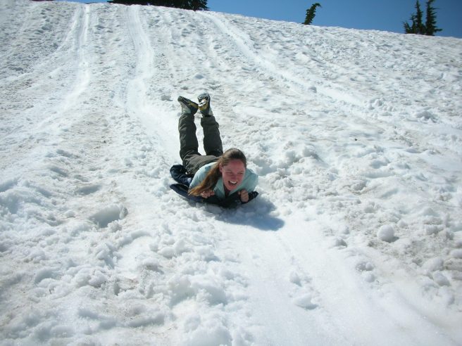
At some of the landing sites we did some snowshoeing which was new to both of us and good fun. Not as fun as sliding back down the hill after though!DSCN8577.JPGDSCN8578.JPGDSCN8587.JPG

Perhaps the coldest part of our trip was the Polar Plunge, which at about -1 Celsius was something of a rite-of-passage not to be missed (side note for the Ellistons – it was even colder than The Moorings!):DSCN8605.JPGDSCN8610.JPG

We camped out on Antarctica one night in sleeping bags and waterproof bivvy bags, which we laid in ice-graves that we dug into the snow – no tent! Our campsite was shared with some crab-eater seals and a few curious penguins:DSCN8617.JPGDSCN8619.JPG

After a sound five hours of sleep out on the ice we were straight on the water to do our kayaking which was good fun!DSCN8633.JPG

At some of the landing sites you can see the evidence of whaling in the days when industry was allowed:DSCN8664.JPG

We visited Port Lockroy, a British research base that is manned during the summer (presently by four ladies) and includes what is certainly the most remote post-office we’ve ever visited!DSCN8692.JPGDSCN8687_no_red_eye.JPGThe penguins here were so used to people that they had nested right up to the post-office door, allowing us to get close enough to see their little chicks between their legs:DSCN8679.JPG

More snowshoeing…DSCN8713.JPG… and more sliding back down…DSCN8734.JPG

To give an idea of the scale of Antarctica, we only visited the Peninsula which sticks out from the main continent. It was a fair way from there to the South Pole:DSCN8738.JPG

We saw some awesome glaciers where they meet the water with skyscraper-sized pieces of ice arranged precariously and just waiting to fall at any moment:DSCN8762.JPG

Penguins were not the only birds we saw. There were the massive albatrosses on the Drake passage, various other birds that we don’t know the names of and this cormorant:DSCN8769.JPG

We had good weather on average, but not every day:DSCN8790.JPGStill, we didn’t let that stop us from enjoying the view and seeing seals from the boat!DSCN8795.JPGDSCN8813.JPGDSCN8820

We did some cruising around an “iceberg nursery” with colossal towers of ice peering eerily from the misty snowy clouds, whilst we listened to the guides on the radio trying to figure out where in the grey mist our boat was located!DSCN8821

One of our more snowy landings was an opportunity to see a juvenile elephant seal that was snoozing in a cleft in the rock. These seals are the largest in the world, and an adult male can grow to around three tons! They smell and sound like bad plumbing.DSCN8855

There are multiple types of penguin in Antarctica. The biggest are the emperors, but you can’t find them on the Antarctic Peninsula, so we could not see them. Most landing sites are smothered in gentoo penguins, which are the ones we’ve put pictures of on this blog up to now. The gentoos have a varied diet which has benefited them as climate change has modified the ecosystem. Another type of penguin that calls the Antarctic Peninsula home is the Adélie penguin. Adélie’s are krill eaters, so the reduction in krill has hit these chaps hard and their numbers are dropping fast, with gentoos moving in to take over the vacant nesting sites. We did get to see some Adélies on one landing – they don’t have any coloured beak (unlike the gentoos) and they usually have their eyes wide open like they are permanently surprised. The picture below has both a gentoo and an Adélie front centre.DSCN8839

You can take the English out of England, but they will take tea with them.DSCN8867

We tried some arty shots, especially around sunset (you have to be quick as it only lasts about 4 hours…):DSCN8872DSCN8878DSCN8908DSCN8909DSCN8949

They’ll let any old idiot drive a cruise boat these days:DSCN8959

Finally, on our last full day we got to do the activity that we were most looking forward to: mountaineering! We were to climb Spigot Peak. The zodiac dropped us, we geared up in snowshoes, harnesses and then roped together in a line so that if someone slipped then the rest of us would prevent them falling too far. The peak is behind Zoë in the photo below (she’s also hiking in a T-shirt!).DSCN8977.JPGAfter an easy thirty minutes of snowshoeing we changed to crampons to hike the steeper section to reach the summit. It also gave us a chance to look at a colony of a different type of penguin: chinstrap penguins!DSCN8982DSCN9028DSCN9029Final approach to the summit, with Zoë second on the rope and Joe third.DSC_0014.JPGThe summit was awesome!DSCN9007DSCN9015DSCN8997.JPGWe didn’t get to do any ice climbing in Antarctica, but we did get to pretend…DSCN9023

During lunch later that day the loudspeaker announced that some orcas (killer whales) had been seen near the ship. Never had the restaurant emptied so fast. The orcas were hunting near the boat, and at one point surfaced right behind the ship. Our camera wasn’t up to the job of catching them, so thanks to Roger for sharing these awesome photos with us!IMG_3780.JPGIMG_3875.JPGSpy-hopping!IMG_3746.JPG

Before we left Antarctica we visited some of the islands further north, starting with the South Shetland Islands. The really unusual thing we saw here was a leopard seal on the beach – the expedition leader said that they had only ever seen them in the water before. They eat penguins, so this gentoo was being rather brave:DSCN9145We waved goodbye to another juvenile elephant seal…DSCN9166… and a few thousand more penguins!DSCN9185

Our last stop was Deception Island – the caldera of an active volcano. Our boat navigated through the small inlet channel to the lake inside the crater. We landed the zodiac at a steaming beach (though unfortunately the water was not exactly tropical…) and took our last opportunity to do a hike up a nearby peak.DSCN9232DSCN9242DSCN9248DSCN9253

The journey back was… easy! They call it the “Drake Lake” in these circumstances where you are lucky enough to avoid the waves. The captain could therefore keep the throttle max and we made the crossing much earlier than expected, giving us time to make a detour to visit Cape Horn – the infamous bottom edge of South America that has wrecked many a sailing boat in centuries past.DSCN9278

Chile & Argentina – Part 1

San Pedro de Atacama is an oasis town in the desert. We thought we’d better start by getting up close and personal with the sand by going sandboarding:25073120_1506839312717648_6495899406128397499_o25311202_1506842079384038_4298213421466733247_o

Valle de Luna had vast moon-like landscapes, where the sand looked like snow:DSCN1352DSCN1354

We visited numerous lakes with striking colours and also floated in one with high salt content:DSCN1388DSCN1446DSCN1457.JPGDSCN1466.JPGDSCN1402.JPG

There was a surprising amount of wildlife for a desert, including more flamingos and an Andean fox:DSCN1419DSCN1450.JPG

Further south, pretty flowers gave the place an alpine feel:DSCN1426.JPG

Rainbow Valley wasn’t as brightly multi-coloured as you might expect, but was still pretty cool:DSCN7769

Last stop on our long driving tour was the world’s highest geyser field – luckily they let us in, despite getting there after closing!DSCN7808.JPG

Next we went to Salta, Argentina. The roads were quite “interesting” in parts, and after one particularly nasty section of deep soft wet sand in the middle of nowhere we had to figure out how to fix a flat! When we finally made it to the nearest town, we discovered the other road out was closed due to flooding and we overheard a hostel owner saying the road we arrived on was fine – ‘just a little sandy in one section’ – our flat tyre begs to differ!DSCN8018

The main attractions around Salta are the many gorgeous coloured rocks:DSCN7877DSCN7898DSCN8001

We’re usually pretty blasé about waterfalls, both having seen awesome waterfalls in Iceland before. However, Iguazu Falls really took our breaths away. Almost 300 waterfalls, sitting on the border of Argentina, Brazil and Paraguay. We spent a day on the Brazil side (better panoramas) and a day on the Argentine side (closer to the action). We also made friends with a very playful puppy, who lived on our front doormat.

DSCN8155DSCN8192DSCN8272DSCN8241

We spent Christmas in Ushuaia – the southern-most city in the world. It was stunning, from the plane ride in over the snow-capped mountains, to the reflections in the lakes and sea and the scenic hiking. We couldn’t resist a bit more sledding too!DSCN8320DSCN8329DSCN8348DSCN8374DSCN8378

Ushuaia and the nearby national park of Tierra del Fuego like to refer to themselves as “the end of the world”, with places such as “the post office at the end of the world”. There is definitely a frontier feeling about the place. But this was not the end of the road south for us, as Ushuaia was our embarkation port for our journey further south to the land beyond the end of the world…

Bolivia

You may have noticed an increase in our blogging of late – we’re trying to get up to date in the next few days before we fly back to the UK (yikes!).

Bolivia is high – La Paz airport is at 4200m, and the city itself is only a bit lower at 3800m, so we didn’t do much for the first couple of days whilst we acclimatised. The city has a novel means of public transportation, using gondolas, which are well suited to the steep gradients that would be impassable by trains. Apparently in a few years you will be able to take a gondola from the airport into the centre of the city!DSCN0606.JPG

Our first destination was the national park of Sajama, which lies about 4 hours drive south west of La Paz. Everything was very basic here in a small village at the foot of Bolivia’s highest mountain – Sajama. Our hiking intentions were more modest, and we hiked up to three high alpine lakes, passing by geysers, cute rabbit-like things and also walking into Chile along the way:DSCN0642.JPGDSCN0656DSCN0667.JPG

Back in La Paz we took a taxi to Chacaltaya – which used to be the world’s highest ski resort until the glacier melted, so now it is just a viewpoint that is accessible by a harrowing 2 hour drive along a tiny road that clings to the mountainside. The view from the top was pretty cool!DSCN0772.JPGDSCN0785.JPGWe decided to bike the Death Road, which is now much safer since the majority of the vehicular traffic uses the new bitumen road instead. P1080128P1080172.JPGP1080232.JPGP1080267.JPG

We travelled to Isla del Sol out in Lake Titicaca, with the journey being an adventure in itself with our bus having to be taken over part of the journey on a highly robust raft:DSCN0793.JPGThe island itself is quiet, peaceful (there are no cars) and pretty. DSCN0809.JPGWe decided to go for a quick hike, and after only about 30 minutes encountered a house with a barrier. Apparently the locals had decided to close of about 85% of the island to tourists (Joe is pointing to the line that demarcates no-tourist-land). It was rather frustrating that this information was not available to us before we arrived on the island!DSCN0813.JPGDSCN0832.JPG

We decided not to attempt a multi-day trek in the Cordillera Real, the massive mountain range near La Paz with 6000+ metre mountains, since the weather was not very stable at the time of our visit. However, we did make it up Pico Austria, a small peak (only about 5400m…) with great views over the rest of the range. We arrived to a snowy landscape and then climbed steadily to a great view:DSCN0854.JPGDSCN0868.JPGDSCN0889.JPGDSCN0882.JPG

Our final destination in Bolivia was to the salt flats of Uyuni in southern Bolivia. Now famous (among some) as the filming location for the salty planet towards the end of Star Wars The Last Jedi, this is a great place to visit for fun false perspective photos, a train graveyard, massive cacti trees, lagoons filled with flamingos, bubbling pools of volcanic mud, a tree made of rock and altogether a rather novel landscape:DSCN0925.JPGDSCN0944DSCN0981.JPGDSCN1035DSCN1031DSCN1043.JPGDSCN1044.JPGDSCN1066DSCN1073.JPGDSCN1096.JPGDSCN1130.JPGDSCN1158DSCN1178.JPGDSCN1243DSCN1269.JPGDSCN1260.JPGTours of the salt flats from Uyuni either end in Uyuni, or in San Pedro de Atacama in Chile. We did the latter. Our top tip is to do the trip from the Bolivian side rather than the Chilean side, as it is about twice the price to do it from Chile.

Ecuador

This is a small country with a lot to offer. To the east is rainforest, of which we visited only a small part on a four day trip to Cuyabeno. This part of the rainforest has many flooded lagoons, which were both transit arteries and eerie places to visit in the morning fog:DSCN9718.JPG

Wildlife ranged from black and yellow birds that built nests that hung like stockings from the trees…DSCN9738.JPG… something like ten species of monkey of which we saw about seven…DSCN9741.JPG… frogs that get everywhere…DSCN9829.JPG… a fungus that reproduces by turning bugs into zombies and then sprouting from the head of the dead bug…DSCN9748.JPG… trees that can actually walk towards light in the canopy (!) …DSCN9752… a giant anaconda…DSCN9766.JPG… and pink river dolphins that we saw but proved too hard to catch on camera!

Next we visited the Galapagos Islands. Most tourists visit this on a cruise, which has the advantage that some sites are only accessible by cruise boats. However, from experience we know we don’t much enjoy sleeping on a boat so we decided to travel independently and sleep on the islands. It’s also much cheaper to travel independently. We began in San Cristobal, where we did some diving and short hikes, but the main cool thing was the abundant sea lions, including some adorable playful pups:DSCN9879.JPGDSCN9897.JPGDSCN9928.JPGDSCN9970.JPGDSCN9961.JPG

Then we flew Brass-Airways to Isabella:DSCN0002.JPGIsabella is home to vast numbers of marine iguanas. When they are not eating sea-algae they like to stare at the sun with their eyes closed:DSCN0030.JPGThere are also many white-tipped reef sharks (which are harmless):DSCN0033We had good fun swimming with a couple of sealions near Isabella, although it was first necessary to get past a blockage on the path:DSCN0037.JPGJust beside the town was a waterhole that was popular with the local flamingos:DSCN0054.JPGThe Galapagos is famous for its giant tortoises, which were decimated by early explorers and the surviving species are being bred for re-introduction to the wild:DSCN0071.JPGAnd we just found Isabella to be generally laid back and good fun:DSCN0115.JPGThe islands are volcanic in origin, and Isabella has one volcano that is very easy to visit, so we did just that:DSCN0177.JPGDSCN0199.JPG

We travelled to our third and final island of Santa Cruz by ferry (which broke down for a while). As well as having the biggest city in the islands, this also has many of the usual Galapagos things like tortoises…DSCN0225.JPGDSCN0232… one of the prettiest invasive species of flower ever…DSCN0249.JPG… lights at the harbour which were useful for both humans and pelicans to see the fish below…DSCN0253.JPG… birds called “blue footed boobies”…DSCN0255.JPG… and scenes that just don’t happen outside the Galapagos…DSCN0292.JPGDSCN0296DSCN0307.JPGDid you spot the sealion in the last picture?

Under the water we were particularly excited to see Mola Mola (also known as the Sun Fish), Hammerhead sharks and many many rays.

After the Galapagos we flew to Quito and travelled south to Banos. Enroute we saw Volcan Cotopaxi:DSCN0340.JPGBanos is an activity town where we did some white water rafting, canyoning, a little hiking, and also just spent some time swinging around:DSCN0382.JPGThey also have some waterfalls in Banos…DSCN0404.JPG… white water rafting…RIMG0055.JPG… and paragliding!DSCN0442.JPGDSCN0459.JPG

We drove to the crater lake at Quilatoa, at around 4000m above sea level. Since we were not acclimatised we decided not to hike around the crater.DSCN0479

We hiked up Cotopaxi to the refuge, and then onto the glacier at 5200m. Unfortunately the weather was against us.DSCN0489.JPG

Our final stop was in Quito, where we prepared for our journey to Bolivia!DSCN0499.JPGDSCN0517.JPG

Mexico

After 4 months of easy travelling in the USA, it was a bit of a shock arriving in Mexico, from stray dogs hoping for a bit of burrito to children driving cars.

DSCN9310.JPG

DSCN9327.JPG

We didn’t make it easy for ourselves, by starting in tiny Creel. Few people spoke English and there weren’t really any tour agencies or even taxis!

Nevertheless, we still managed to have some adventures. Quad biking around Creel (luckily our guide knew how to fix his quad bike when it broke down!):DSCN9316.JPG

DSCN9318.JPG

Ziplining (including the world’s longest at 2.5km), abseiling and via Ferrata in the Copper Canyon:

DSCN9331.JPG

DSCN9373.JPG

DSCN9367.JPG

DSCN9381.JPG

DSCN9430.JPG

Sampling tequila the local way:

DSCN9467.JPG

Mexico is full of history, culture and ancient ruins. This is Teotihuacan, a 20 sq km complex of pyramids, which was once Mesoamerica’s greatest city. It was built between the 1st and 6th centuries AD and abandoned by the 8th century.

DSCN9539.JPG

Chichen Itza, a Mayan city, which was abandoned twice:

DSCN9634

We decided to shift our flights back one day, so we could be in Mexico City for Day of the Dead. Locals make colourful shrines to remember loved ones who have passed away. It is a happy celebration, rather than a sombre affair.

DSCN9569.JPG

Since featuring in James Bond though, the day has become more touristy. In fact, there didn’t used to be a parade, until one was created for James Bond filming and the city decided to repeat it each year from then on.

DSCN9587.JPG

IMG_20171028_174351533.jpg

Next stop: Ecuador!


The Wild West – part 3

AROUND KANAB
Kanab is a town in southern Utah, whose tagline is “the greatest earth on show”. We had six nights here, not for the town itself but for the nearby attractions, and in particular the very popular walk to see The Wave. To reduce erosion, only 20 people are allowed to see this per day, with ten permits being issued in advance online via a lottery. We applied for this, but were not surprised to be unsuccessful since only 4% of advanced applications are successful. The remaining ten permits are issued one day in advance via another lottery, where applicants must apply in person at the visitor centre in Kanab. Hence we had six nights there to give us a reasonable probability, though we calculated that even with six nights the odds of our success were about 40%.
Our first hike in this area was to the South Coyote Buttes, which was definitely an adventure. Getting there was hard enough, up an access road of soft sand that was a struggle in our car since we couldn’t lower the tyre pressures, so we only made it part-way before chickening out and hiking the last part.
DSCN8342.JPG
We’d been given a poor map of the area by the park authority, and there was no trail to follow, so we just made up our visit.
DSCN8350.JPG
DSCN8351.JPG
DSCN8363.JPG
DSCN8364.JPG
DSCN8382.JPG
The lack of a path, the large size of this area of the park and an annoying barbed wire fence running through the bit of the park we wanted to cross led us to only visit the southern part of the South Coyote Buttes. On the way out we encountered the Painted Desert, named after the very stark and pretty colours on display:
DSCN8405.JPG
Near to Kanab is an animal rescue centre, which has an awesome $5 all you can eat vegan lunch buffet – quite an oasis in the heavily meat-eating state of Utah. We “volunteered” at their cat sanctuary for an afternoon, where it seemed that our only duty was to play with the cats. As we’re sure you can imagine, this was hard work. We even got to take some cats for a “walk”, but apparently no-one told the cats this as they thought it was nap time.
DSCN8467.JPG
DSCN8474.JPG
DSCN8481.JPG
We took another trip to the South Coyote Buttes, this time on a tour in a hummer – a somewhat better vehicle for driving on all of the soft sand:
DSCN8669.JPG
This time we were visiting the northern section of the South Coyote Buttes, which was DEFINITELY better than the section we visited before. The colours in the sandstone are out of this world…
DSCN8518.JPG
DSCN8527.JPG
DSCN8547.JPG
DSCN8557.JPG
DSCN8564.JPG
DSCN8591.JPG
DSCN8617.JPG
DSCN8620.JPG
DSCN8633.JPG
DSCN8647.JPG
DSCN8651.JPG
The other half of hummer tour was to see White Pocket, another remote area that we did not dare to drive to ourselves. The main attraction here is the bizarre brain-shaped rocks:
DSCN8680.JPG
DSCN8686.JPG
There are also lots of lovely colours and shapes in the rock:
DSCN8701.JPG
DSCN8710.JPG
DSCN8720.JPG
DSCN8727.JPG
The plants made pretty patterns in the sand too:
DSCN8700.JPG
On the seventh and last possible morning that we could apply for a permit to hike The Wave, we were successful! So the next day we set off along a bare-rock valley with a sheet of instructions for finding the way, along a valley that looked like this:
DSCN8770.JPG
The Wave is relatively quick to visit (unless you want to explore) since there is one main sight to see and it’s only about an hour’s walk to get there. This probably should be on a list of natural wonders of the world…
DSCN8781.JPG
DSCN8801m.jpg
Naturally, we did some further exploring around:
DSCN8803.JPG
DSCN8823.JPG
DSCN8838.JPG

GRAND CANYON – NORTH RIM
Only 10% of visitors to the Grand Canyon make it to the North Rim since it is a five hour drive between here and the South Rim, and the views from the South Rim are probably superior. The drive from the entrance station to the rim itself is pretty, past meadows full of bison (when we visited anyway…) and yellow Aspen trees.
DSCN8418.JPG
There are the usual set of viewpoints that you can stroll to with a cuppa in hand:
DSCN8421.JPG
And there are also some short hikes of up to a few hours to other viewpoints, where all views are inevitably looking down into the canyon and over to the South Rim some ten miles away.
DSCN8449.JPG
The scale of this place is epic, and you need to stare at it for a while to really appreciate it. There is also a multi-day hike that you can do from the North Rim to the South Rim, and if this works for you logistically then that sounded like a great adventure!

MONUMENT VALLEY
Home to many famous viewpoints, we decided to swing by Monument Valley on our way to the South Rim of the Grand Canyon. There are basically two things to do here: The first is to stay at The View hotel and look at the view outside:
DSCN8885.JPG
In retrospect, this was very expensive and you can see the same view for free if making a day trip, but it depends what floats your boat. The second thing to do is to drive the dirt road that runs through the valley, which takes a few hours and is definitely worthwhile.
DSCN8903.JPG
DSCN8912.JPG
We wouldn’t advise attempting this in a low-clearance car though if you want to enjoy the ride!

ANTELOPE CANYON
This hit the tourist radar big time a few years ago when the USA congress couldn’t agree on a budget bill to extend the national debt and the government went into automatic shutdown – meaning that all of the national parks closed automatically. Tour agencies in the Grand Canyon/Monument Valley area then scrambled around for things to do with their bus-loads of visitors and the native American owners of the Antelope Canyon area came up with the goods, and tours have continued since. This is an epic slot canyon formed when floodwater is forced to travel through a narrow constriction in the sandstone, creating flowing wave shapes up to 30 meters high.
DSCN8924.JPG
DSCN8928.JPG
DSCN8960.JPGNearby is the Horseshoe Bend hike near Lake Powell, which is a short stroll to an entrenched river meander and definitely worth it!
DSCN8967.JPG

GRAND CANYON SOUTH RIM
Plan your visit here. With care it is a great place with wonderful views and walks, but if you just turn up you will have nowhere to stay, the campsites will be booked out and you may hit big traffic jams and have a rubbish time. Arrive early! Two of our three days here were spent hiking down into and back out of the canyon and so we were immune to most of the crowds. We hiked down the Bright Angel trail, camped overnight at Phantom Ranch and then returned via the Kaibab Trail. It’s probably better to hike it in the other direction, since there is nowhere to refill with water when walking uphill along the Kaibab, but timings worked better for us to hike it this way to squeeze in a couple of side trips. The views walking down the Bright Angel Trail are superb, and you just descend layer after layer of canyon in an amazing mile of vertical descent:

DSCN8979.JPG
DSCN8987.JPG
DSCN9021.JPG
We camped at Phantom Ranch, where we ate an awesome dinner of all you can eat beef or veggie stew and we could even purchase wine at a reasonable cost!
DSCN9038.JPG
Hiking out was similarly scenic, and you hike up in time along a geologic history of the planet, starting at the bottom of the canyon with rocks that are around 2 billion years old!
DSCN9057.JPG
DSCN9080.JPG
If such an epic hike isn’t your thing, rest assured that you can see some amazing views easily enough from the canyon rim:
DSCN9100.JPG

DEATH VALLEY (TATOOINE)
Our last USA national park! It was near 50 degrees Celsius a few weeks before we got there, but luckily for us the temperature dropped to something more reasonable for our visit! The ground here seems to be either mudstone or just loose sand, which gives the place an interesting feel:
DSCN9145.JPG
For tour bus visitors, your experience may be like this:
DSCN9143.JPG
But thankfully for us the buses left soon and we had most of the places to ourselves. We were particularly interested in finding some Star Wars (A New Hope) filming sites in Death Valley from the planet Tatooine, including the overview of Mos Eisley:
DSCN9149.JPG
…the sand dunes where R2D2 and C3P0 part company:
DSCN9218.JPG
… and the valley where R2D2 drives up before he is captured by the Jawas (the little red-eyed chaps in hooded cloaks):
DSCN9205.JPG
There were a bunch of other Star Wars sites for the harder-core fan! There is also a seriously cool salt lake to visit, which is made of jagged interlocking plates of salt extending off into the horizon (and if you sat quietly you could hear the salt crystals cracking as they expanded/contacted in the heat):
DSCN9170.JPG
We also visited Badwater Basin, at 85m below sea level, and had some fun taking photos:
DSCN9189.JPG
DSCN9201.JPG
A random coyote at the side of the road:
DSCN9253.JPG
We didn’t have time for the Joshua Tree National Park, but luckily there were a bunch of these trees on the way south out of Death Valley so that made up for it a bit:
DSCN9257.JPG

That’s all folks – for the USA anyway! If any of this blog has whetted your appetite to visit the USA national parks, our top tips are to get the inter-agency pass ($80 for one vehicle, giving entry to all national parks for a year), hire a reasonably good car as many of the park roads really need an SUV, use the website “alltrails” as an awesome source of information on hikes all over the USA and make sure you speak to rangers when you arrive as they know which trails are open/closed/good. Enjoy!
From Death Valley we just drove back to LA, returned our car and continued on our merry way south… to Mexico!

The Wild West – part 2

We’ve just got back from a long boat journey (but that’s another blog post) so we’ve had some time to catch up on our blogging a bit!

Our visit to Seattle (and in fact the timing of our entire trip) was planned around the wedding date of our friend Jessica, at whose wedding Zoë was also a bridesmaid. It felt very strange to have smart clothes to wear (thanks Ness, Eric, Jess and Amanda for bringing things over/back for us!).

DSCN6668.JPG

After this holiday from the holiday, we swiftly returned to visiting more national parks…

NORTH CASCADES
A few hours north of Seattle, the North Cascades are an epic mountain range with great hiking around the formidable Mt Baker.

DSCN6675.JPG

One of our top walks of all time was here, called Ptarmigan Ridge, named after the Ptarmigan bird that is perfectly coloured to match the nearby rocks but was so stupid that it could probably be caught bare-handed:
DSCN6721.JPG
Starting from a high elevation, the path meandered gently uphill along the edge of three different valleys, with spectacular views and wildflowers the entire time.
DSCN6719.JPG
Some snow crossing was required which was not for the feint-hearted, but it was fine if you were slow and careful. For budding back-country campers, there were some truly awesome (if windy) campsites near the summit, though we just enjoyed the views before returning.
DSCN6731.JPG
On our ascent of the Sahale Arm, we encountered an unexpected marmot blockage on the path before reaching a rather rewarding lake:
DSCN6767.JPG
DSCN6776.JPG

GLACIER
If you are reading this blog many years from now, then Glacier will be an ironic name for this park, since it will have no glaciers left. Such is climate change. For our trip, wildfires had closed one of our lodges and filled most of the valleys with smoke and so we cut our visit here short. On the upside, the smoke made for some interesting light effects in the evening:
DSCN6798
Due to the wildfires, we decided to give Glacier a miss for a day and travelled over the border to Canada to see Waterton National Park, which adjoins Glacier, where the air was much clearer. Our hike here was pretty, and for one steep section the path went into the mountain which was very cool:
DSCN6827
Though, to be honest, the better view was found from the viewpoint a short 20 minute stroll up a hill right beside the town!
DSCN6845
But Waterton was not really faring much better with the wildfires… as the map of the red restricted areas shows (only a few tiny areas of green were actually open):
DSCN6853
We later found out that they closed the park entirely just a few days after our visit!
Our best hike in Glacier was in the region called Two Medicine, which began with a lake…
DSCN6857
… and continued up to a mountain pass…

DSCN6875

… after which we were nearly attacked by a mountain goat…
DSCN6882
… and then had to make sure we didn’t surprise two large grizzlies who were near the path!
DSCN6893

CRATERS OF THE MOON
This mini-park can be done in a few hours. It’s a volcanic landscape, and all the information boards say something like: “Here is <<insert geological feature here>> which you can see a much better example of if you visit Hawaii”. So, if you’ve not been to the Big Island of Hawaii then give this park a miss or it will just leave you frustrated!
DSCN6905
The visitor centre was interesting for the map outside which showed the origin of international visitors to the park, with Europe, China and India doing very well!
DSCN6898
They also had an equivalent USA map, which is probably a reasonable approximation of a population density graph:
DSCN6897
It seems that people from Mississippi don’t get out as much…

SALT LAKE CITY
A city? In our blog? No, your eyes are not deceiving you! We did in fact visit the Great Salt Lake as we were passing through. Floating in the lake was fun, and it was worth spending an hour or so driving around the island beside the salt lake to see the herds of bison.
DSCN6937

DINOSAUR NATIONAL MONUMENT
The USA has National Parks and National Monuments, but they are both basically the same thing. Most importantly, the annual parks pass that we purchased for $80 works for both (and is an absolute bargain if you are hitting more than two parks). This monument presents the discovered dinosaur bones found here in a wall of an old quarry:
DSCN6957
By far the coolest item found here is a complete Allosaurus skull, which was about a meter in length!
DSCN6958

ROCKY MOUNTAIN NATIONAL PARK
We didn’t originally intend to visit this park, but by leaving Glacier early we had some extra time and we’d heard rave reviews of Rocky so decided to deploy our extra time there. It is high altitude, so if arriving from sea level then remember to take the first day or two gently.
DSCN6985
The weather is quite fickle in Rocky, and on one hike we got a scare upon reaching the summit when Zoë’s hair started raising up on end – indicating that the air was ionising pending a lightning strike! Suffice to say we were down from that summit in a flash (we hope you enjoyed that pun) and captured Zoë’s hair being a bit better behaved once we’d reached a safer zone:
DSCN7056
The best hike we did here was up Mt Ida, which was actually not a formal park trail, but really should be! Early on we passed a rock outcrop we nicknamed Marmot City:
DSCN7099
The path then continued along a ridgeline all the way to the summit, from which we could see almost all the park and dozens of lakes:
DSCN7119
One the way down we were lucky enough to see a pika – a local rodent that specialises in cold high-altitude climates by making underground stores of hay to eat during the long snowy winters. In what felt like a mini-episode of Planet Earth we watched one very cute pika eating for a while, and then make a hay bale to take back home for the larder:
DSCN7131
DSCN7139
Unfortunately these pikas are in serious danger of being lost due to climate change as they are very temperature sensitive.

BLACK CANYON OF THE GUNNISON
On our way to this park we passed a forest of Aspen in full autumnal awesomeness:
DSCN7147
We also unexpectedly passed some beautiful rock formations known as the Dillon Pinnacles, which are definitely not in the guide books but if they were located in a more boring part of the world then they would probably be a feature attraction. We have started to feel that nearby to the national parks are loads of other really interesting things to see if only we knew about them!
DSCN7149
The Black Canyon is easily visited in half a day, unless you fancy hiking down into the canyon and back, but we were feeling far too lazy for that!
DSCN7165
DSCN7196
If you’re passing this is definitely worth stopping at, but it is neither as large as the Grand Canyon nor as pretty at Zion, so perhaps not worth a large detour.

COLORADO NATIONAL MONUMENT
This was our first proper red-rock park. Often overlooked, this park has many of the same features as other parks in Utah, without the crowds. Be warned, however, the path markings leave a lot to be desired.
DSCN7204
The views from the road through the park were great for a while…
DSCN7224
… until the rain closed in and we felt a crushing sense of viewpoint-name irony:
DSCN7234
The next morning was thankfully sunny. With the park being so quiet it was easy enough to find somewhere quiet to sit and enjoy the experience:
DSCN7246

ARCHES
VERY popular, and for a reason, this park has an impressive density of rock arches that even the crowds can’t easily diminish. But it is not all about the arches, with Park Avenue being a particularly impressive short stroll between huge walls of rock:
DSCN7312
Many of the formations are supposed to look like things, but we found it more fun to make things up ourselves:
DSCN7304
The Windows, as seen from inside Turret Arch:
DSCN7337
Double Arch:
DSCN7366
Landscape Arch:
DSCN7487
Double-O arch
DSCN7508
Tower arch was accessed by a dirt road through a river wash, which deters all but a few tourists, making for a better visit. You could easily spend a few hours exploring around here:
DSCN7535
DSCN7543
Delicate Arch, the state symbol for Utah:
DSCN7613
If you get the chance, a visit to the Fiery Furnace is a great experience. This part of Arches park is a maze of canyons which you can explore if you get a permit.
DSCN7624
DSCN7628
DSCN7629
DSCN7637

CANYONLANDS
Located near to Arches, this should also not be missed. The park is split into three parts called “Islands in the Sky”, “Needles” and “The Maze”. Visiting The Maze requires a serious 4WD adventure so we skipped that. Islands in the Sky describes the layers of mesas formed by the erosive force of the Colorado River on the nearby sandstone, sometimes leaving rock “islands” and sometimes making impressive canyons:
DSCN7409.JPG
DSCN7429.JPG
The 4WD tracks looked so tempting to explore!
DSCN7380.JPG
In case you haven’t seen enough arches in Arches, don’t fret, there are more here:
DSCN7455.JPG
Located beside Canyonlands is the Dead Horse state park, which has a great view of the canyon and is also famous for being the end of Thelma and Louise’s car journey.
DSCN7464.JPG
DSCN7465.JPG

CAPITOL REEF
Another lesser visited park, this is named a “reef” after the shape of its main rock feature – the Waterpocket Fold which is a pretty eroded range of cliffs with lots of nice colours:
DSCN7882.JPG
DSCN7901.JPG
DSCN7930.JPG
We spent about two days here which seemed enough, with a long scenic drive and some nice short hikes.

KODACHROME
This is a state park, and the usual rule applies: they are less good than the national parks in general, but if you are driving past (as we were) then you may as well drop in! This was another coloured rock place, and also had some unusual pillar rock features of unknown origin.
DSCN7989.JPG
DSCN7967.JPG

BRYCE
It’s easy to understand why Bryce is such a popular park to visit:
DSCN8029.JPG
Many visitors only see the viewpoints and short strolls from the rim drive, and these are a must for any visitor’s itinerary. But if you have time we’d highly recommend hiking down into the canyon and walking around between the colourful shapes of rock:
DSCN8038.JPG
Some of the rocks are supposed to look like things, the two best we saw were Queen Victoria and ET:
DSCN8086.JPG
DSCN8088.JPG

CEDAR BREAKS
Less visited, Cedar breaks is geologically similar to Bryce, and sits at a high elevation which meant that it was snowy for our visit:
DSCN8140.JPG
The attraction here is the massive amphitheatre. There are a few walks that can be done down into this amphitheatre, but we were not convinced that they were worth doing, and it felt like the cold and the altitude was getting to us so we just whizzed around the main viewpoints and then hit the road.

ZION
This park is gorgeous. It consists of one massive canyon, but if you only drive into and out of the canyon then you are really not doing justice to this place. For starters there is the whole Kolob Canyon area of the park that is a good 2-3 hour drive from the main part of the park:
DSCN8151.JPG
There were also loads of nice autumnal colours in the areas around the park:
DSCN8167.JPG
One of the most popular hikes in the park is The Narrows, where you hike up a river with canyon walls either side of you. Depending on the time of year, you will need to swim at some parts, and sometimes the walk is closed if there is a danger of a flash flood. You really need proper boots designed for hiking in cold deep water over stones, whereas we just hiked in a short way in water sandals and found it far too freezing to want to go further. Your mileage may vary, but this felt like a hike that was popular for being popular, rather than being particularly awesome.
DSCN8181.JPG
Our top recommendation for hiking in this park is the West Rim trail. Unless you want to camp, or feel up to a 30 mile return day-hike, you need a shuttle to take you to the trailhead in the west end of the park and then you hike 14.2 miles back downhill into Zion Canyon. The majority of this is relatively flat hiking on the high plateau, with truly superb views:
DSCN8191.JPG
DSCN8212.JPG
DSCN8224.JPG
DSCN8236
The last third of the hike is the descent to the canyon bottom, and close to the end is an adventurous addition to the hike: Angels Landing, the rock pinnacle in the middle of this picture:
DSCN8249
This little scramble is assisted with chains and a few handrails, though they were about to embark upon some work on the trail the day after our visit, so it may be safer now!
DSCN8253
There is also an East Rim Trail, which again needs a shuttle to the start, and is a full day hike back into the canyon. This hike is OK, but not nearly as good as the West Rim Trail. As we approached the canyon at the end then the views started to get quite interesting:
DSCN8282.JPG
We had to side-step a snake on the path which was quite cool:
DSCN8281
Near the end of this hike we joined up with the much more popular Observation Point trail, which we would highly recommend, both for the cool slot canyon parts of the trail and the panorama from the top:
DSCN8287.JPG
Arachnophobics beware, there are tarantulas in Zion!
DSCN8316.JPG


The Wild West – part 1

As usual, we’re rather behind in our blogging. Sorry! We’re currently in La Paz, struggling to breathe at 4000m and blogging because Bolivia has judicial elections today and basically EVERYTHING in the country stops working for a whole day. But this blog post is not about Bolivia, it is about the continental USA where we focused just on the western and mountain states.

We’ve been to so many parks in the USA now so we thought we’d do a mini-summary of each one. We’ve split this into two parts, firstly our trip north to Seattle, and then our return trip south. Since we are both analysts, we naturally begin with some caveats. This only covers the western part of the continental USA, and obviously only the places that we went to on this trip. Yellowstone and the Grand Tetons are two epic parks that will not feature for this reason, but these are quite possibly our favourite parks. Also, we review things from a view-junkie’s perspective, so forest walks to a quaint waterfall will score poorly. Your mileage may vary.


SEQUOIA AND KINGS CANYON

Sequoia has the largest trees by volume in the world. Considering that these are easily accessed by road, it’s worth visiting even if you’re not a big tree fan.

DSCN5414DSCN5416DSCN5472.JPG

But there is more to Sequoia than big trees. Like it’s more famous neighbour Yosemite, Sequoia has lots of exposed grey granite hills which make for great hiking and enjoyable scenery.

DSCN5530.JPG

But the real gem is Kings Canyon, which adjoins Sequoia. The drive in itself is about 90 minutes of stellar views (and slightly precipitous corners) and the last section follows an impressively powerful whitewater river for about 30 minutes. The destination has meadows to stroll in and hills to hike up (though we cheated on the largest hill and drove up the 4WD track most of the way!).

DSCN5598.JPG


YOSEMITE

Definitely one of America’s most popular parks, but most visitors will only visit the valley. DO NOT do what we did and arrive at 10:30am on a Saturday, to have to wait 1 hour in traffic to find a parking space. That was horrible. Arrive early. The valley itself is impressive, albeit quite smokey when we visited due to nearby wildfires.

DSCN5644.JPG

You can walk all around the nearby hills. The best view may be that from Sentinel Dome, where you get a good view of the famous Half Dome:

DSCN5655.JPG

Climbing Half Dome is a fair challenge and not for the unfit or faint-hearted. It also takes lots of planning as there is a lottery system to get tickets, and we had to enter half a dozen times before we had any luck. We started hiking before first light for that long but very interesting day. The famous part of the hike is the cables at the end that allow non-climbers to safely reach the summit up a smooth granite slope at about 45 degrees, and the views at the top were awesome!

DSCN5799

DSCN5819.JPG

DSCN5814.JPG

On other days, the wildfires really did make walking kinda pointless.

DSCN5698.JPG

On one of these smokey days we decided to volunteer in the park which involved learning about and removing some invasive plants. Many parks have such volunteering opportunities and they can be quite fun.

Yosemite is also the self-styled world capital of rock climbing. We gave it a go. Climbing on granite is hard on the hands, since the rock is abrasive and you are often climbing using cracks rather than rock protrusions/ledges, but definitely a good experience nonetheless.

DSCN5852

North of Yosemite is the Tuolumne Meadows area, which is higher in elevation and so more alpine tundra than forest. This suits us, because this means fewer trees and so better views whilst walking. But it is far from barren:

DSCN5768.JPG

In this area we did one of our favourite hikes of all time, to Gaynor Lakes. The lakes themselves are pretty and very easy to get to, but the walk was so good because we could extend it and explore the hills around, leading to some glorious views:

DSCN5939.JPG

DSCN5943.JPG


MONO LAKE AREA

As you drive east out of Tuolumne Meadows you drive right by Mono Lake. We’d not planned to visit this, but our lodge in Tuolumne had been damaged by the severe snowfall the winter before and so was not opening for the season, giving us a few spare days to see Mono Lake and the area. We’re glad that we did see this. Mono Lake is a salt lake where various large rivers ultimately meet their end without ever making it to the sea.

DSCN6009.JPG

We went for a swim in it, and could float fairly well (but not as well as we could in the Great Salt Lake beside Salt Lake City later in the trip). The lake had a bizarre ecosystem, containing two main organisms that the eye can see: brine shrimp and alkali flies. These two provide migrating birds with food when they make a pit stop during their travels and the flies also form a layer around the edge of the lake that fly up into a harmless black cloud when you get near which is quite cool to experience. The lake also has strange rock formations caused by petrified springs:

DSCN5993.JPG

Following a ranger’s advice, we also found some other mountains nearby which, by virtue of not being in a named park, were almost devoid of other hikers. The flip side of that is that it was also devoid of a path for much of the time!

DSCN6042.JPG

DSCN6038.JPG


LASSEN VOLCANIC NATIONAL PARK

This is definitely one of the lesser visited parks, but there is some good stuff to see here. We did two larger summit walks, Lassen Peak being particularly memorable because there were millions of butterflies migrating across the upper reaches of the mountain and flying all around us as we walked (every black spot is probably a butterfly).

DSCN6070.JPG

There we also some pretty semi-iced lakes to see:

DSCN6122.JPG

And some snow slopes to toboggan down:

DSCN6119.JPG

There are various smaller-scale thermal features to visit on a chilled out evening walk…

DSCN6163.JPG

…where the ground was often coloured in interesting ways:

DSCN6162.JPG

It wasn’t all about peaks and thermal features though. Some of the hikes were memorable for the myriad of flowers along the way:

DSCN6178

DSCN6183

But, let’s be honest, our favourite hike was probably our other summit hike 🙂

DSCN6197.JPG


CRATER LAKE

Crater lake, no surprises, is a crater with a lake in it. It’s pretty huge and you can (normally) drive around it in about 3 hours. We say “normally” because half of this park was shut when we arrived due to (you guessed it…) wildfires!

DSCN6209.JPG

Since the air was beyond safety limits we cancelled our accommodation and made a speedy getaway north (because there wouldn’t be any wildfires there, right?).


MT HOOD

Mt hood is a ski area and we’d planned to go up the cable cars to see the scenery, but the smoke changed our minds. Unusually for us, the real highlight of this visit turned out to be staying at the nice but eerie Timberline Hotel, which was the setting for the film The Shining.

DSCN6232.JPG

Next door to Mt Hood is the Colombia River Gorge which we thought we’d swing by on our way out. This is a destination for waterfalls, some hiking, and (on the day we visited) seemingly half of the residents of Oregon state in their cars all trying to find parking spaces. With the hikes too smokey and the roads too insane, we were glad to escape!


MT ST HELENS

This place is definitely worth a quick visit. We did a half-day hike along a ridge with views of Mt St Helens (again, sorry about the smoke).

DSCN6264.JPG

The end of the hike was surprising: The last big eruption (maybe in 1980) of the mountain had decimated the forests in the vicinity, and the carcasses of their trunks still choke up a huge lake near the foot of the volcano, just about making it look like you could walk over the water on the wood!

DSCN6280.JPG


RAINIER

This is justifiably one of the more popular parks and we easily spent over a week here. Everything is centred around the massive Mt Rainier. We started in “Paradise” in the south which has beautiful meadows and mountain views:

DSCN6350.JPG

DSCN6345.JPG

Apart from some other hikes in this area, we also took part in a morning of volunteering to help repair the paths which was good fun.

The other main place to visit is called “Sunrise” which is in the north of the park. This has stellar hiking, and in retrospect would have made a great place for a wilderness backpacking adventure. But we were far from disappointed with our day hikes there:

DSCN6377.JPG

DSCN6378.JPG

The view away from Mt Rainier was also pretty good (spot the large marmot lazing on a rock in the centre bottom of the picture):

DSCN6472.JPG

We also visited the lesser-used “Carbon River” entrance to the park for another hike, again with views dominated by Rainier, albeit from a different perspective.

DSCN6500.JPG


OLYMPIC

This national park is situated by the coast, to the west of Seattle. Our first hike was cloudy at the summit, but we were entertained by some mountain goats, including this baby:

DSCN6510.JPG

By the way, if you are hiking in Olympic and get that feeling that you’re being watched, then look up. The goats appear to be curious of hikers!

DSCN6520.JPG

Olympic has a large road circumnavigating an area of mountains that can only be reached by a multi-day backpacking trip. We decided to stick to the day hikes around the edges of the park instead, and perhaps our favourite was “Dirty Face Ridge” which has views of mountains one way, and Seattle the other way!

DSCN6553.JPG

For the morning of the solar eclipse, we decided not to drive back down south to see the total solar eclipse (which turned out to be a GREAT decision as people who made this trip were stuck in traffic for around 7 hours each way!) and instead went up the nearby Blue Mountain which had nice views towards the centre of the park:

DSCN6571.JPG

As for the partial solar eclipse, we vaguely managed to photograph it through our eclipse viewing glasses:

DSCN6595.JPG

DSCN6606.JPG

Note the distant Mt Rainier in the background of the above picture! Olympic had a number of other wonderful hikes to do, one of the best of which was accessed via a particularly nerve-wracking stony road with large drops off the side, but the hike was definitely worth it!

DSCN6615.JPG

Olympic sells itself as having a variety of things to see, so we should mention them. Aside from the mountains these include the sea (complete with fog – the weather is usually bad on the coast here).

DSCN6646.JPG

For fans of the vampire Twilight series there is also the town of Forks to see; we stopped only for lunch and in retrospect we’d recommend driving straight through!

Olympic also has rainforest…

DSCN6649.JPG

…and elk.

DSCN6655.JPG